Laya-Gasa Trek
This 16-day trek from Drukyel Dzong to Punakha traverses high Himalayan valleys, alpine pastures, and remote villages. Starting in Shana, trekkers gradually ascend through forests, farmed valleys, and yak pastures, passing Chomolhari and Jichu Drake peaks. Key stops include Jangothang (Chomolhari Base Camp), Lingshi, Shomuthang, Robluthang, Limithang, and the distinctive village of Laya with its semi-nomadic yak herders. Trekkers experience steep passes like Gombu La, Jare La, and Sinche La, enjoy wildlife sightings of blue sheep and takin, and witness local culture and traditional lifestyles. The trek concludes with a descent through Koena to Gasa Hot Springs, offering rest and relaxation before a final drive to Punakha.
In essence: A challenging yet rewarding trek combining Himalayan scenery, high-altitude passes, wildlife, and Bhutanese village culture.
itinerary
Starting elevation: 8202’ at Drukyel Dzong
Ending Elevation: 9,482’ at Shana
Distance: 11.2 miles
Elevation Gain: l,624’
Elevation loss: 0’
Time: 5 – 6 hours
We drive the winding road northwest up the Paro Chu to Drukyel, a ruined Dzong. This fortress, now a burned shell, was once strategic in Bhutan’s defense against Tibetan invasion. Mt. Chomolhari (24,500 feet), the sacred summit, reaches skyward beyond the Dzong. The road ends and the trek begins, following the river gently uphill through a narrowing agricultural valley lined with many farms.
The trail proceeds up a wide valley beneath forest-covered mountains. Bright red chilis dry on the farmhouse rooftops and wheat fields are golden and ready for harvest. The hike today takes us to our first camp in a grove of pines at Shana, which is at the confluence of two valleys. Camp
Ending Elevation: 11,920’ at Soi Thangthangka
Distance: 14.5 miles
Elevation Gain: 2,438’
Elevation loss: 0’
Time: 4 hours to lunch, 3 more hours to camp
We are up early this morning. After having tea and washing water brought to our tents, we have an early breakfast and are on the trail by 8:00 a.m. For many this is the most challenging day, due to both the uneven terrain and the distance. The trail leads us gradually up the river valley, passing farms and re-crossing the river many times. The trail goes up and down quite a bit and the footing is sometimes challenging with many river rocks on the path.
After tea, we climb about 300 feet to a small pass. The trail then levels out above the river and gradually winds down again to cross a cantilever bridge. After the bridge crossing, the trail climbs again and then splits. We take the left hand trail up towards the mountain; the trail to the right (past the chorten) heads to Soi Yaksa.
Our camp is in a meadow near a stone shelter the government has built for trekkers. If the weather is clear, we should be rewarded with a stunning view of Chomolhari. Camp
Starting elevation: 11,920’ at Soi Thangthangka
Ending Elevation: 13,268’ at Jangothang
Distance: 11.9 miles
Elevation Gain: 1,348’
Elevation loss: 0’
Time: 4 – 5 hours
We continue up the Paro Chu, passing a small army post where the valley begins to widen again. The trail climbs to a beautiful flat plateau with a small chorten and then follows the river around a sharp bend. Another brief climb takes us to plateau where our staff will have a hearty lunch waiting for us.
After a hot lunch of noodles and vegetables, we continue, now above tree line, through a spectacular valley lined with snow peaks and several huge waterfalls.
We pass the small village of Jangothang, which has a new health clinic, and within an hour, we reach the camp. This camp is at the base of the ruins of an ancient fortress and (if the weather is clear) we’ll see Chomolhari looming at the end of the valley.
Camp
Group members decide, individually, if today is a trek or “rest” day. There are stupendous day-hikes in three directions. Chomolhari and it’s subsidiary are directly west, Jichu Drake is to the north, and unclimbed summits and ridges are to the east. For those feeling the altitude or just interested in relaxing, one trek leader suggests sitting in camp and watching the shifting light on Chomolhari…not a bad way to spend the day!
It is a beautiful spire peak, like the Matterhorn or Ama Dablam, but is almost completely snow-covered with dramatic hanging glaciers and huge seracs ready to come crashing down. Camp
Starting elevation: 13,268’ at Jangothang
Ending Elevation: 13,156’ at Lingshi
Distance: 13.2 miles
Elevation Gain: 2,380’ (Nglela La, 15,650’)
Elevation loss: 2,494’
Time: 5 – 6 hours
Wide yak pastures line the way up and down the pass and, depending on the weather, some yak herders may still be in their tents. Great views of Lingshi Dzong present themselves as we come down into the Lingshi basin. Tserim Kang and its descending glaciers are at the north end of the valley.
Today is the first day that we use yaks instead of ponies. (By keeping the yaks at the higher altitudes, the yaks are able to remain better acclimated.) Since the yaks are slower than the ponies, we may arrive camp before the yaks. Although there is a stone shelter with an indoor fire pit, it has no chimney and becomes too smoky for most people…so we should be sure to have some warm clothes in our daypacks for our arrival in Lingshi.
Camp
Starting elevation: 13,156’ at Lingshi
Ending Elevation: 12,535’ at Chebisa
Distance: 10 miles Elevation Gain: 340’
Elevation loss: 721’
Time: 3 – 4 hours
Today is a relatively easy day beginning with a visit to the Lingshi Dzong (if permission is granted). Along the way to the village of Chebisa, we’ll watch for more herds of the beautiful Blue Sheep. During the fall, we’ll witness many villagers busily harvesting their fields and preparing for winter.
The village of Chebisa is located in a truly picturesque setting. Beyond the grouping of stone and wood farm-houses, a dramatic rock rises at the far end of the valley; there is also a large cascading waterfall from the top of the cliff. Camp
Starting elevation: 12,535’ at Chebisa
Ending Elevation: 13,035’ at Shakyapasang
Distance: 9 miles Elevation Gain: 1,900’ (Gombu La, 14,435’)
Elevation loss: 1,400’
Time: 5 – 6 hours
A steep climb with breathtaking views takes us to the Gombu La (14,400′) where we should arrive around lunchtime. The trail steeply descends for the first half-hour after reaching the pass and then begins to level out.
We will set up camp at the head of the Shomuthang Valley. Camp
We will spend the day in Shomuthang. The day can be used to relax, catch up with laundry, or explore the environs of Shomuthang valley where numerous day hikes are possible. Camp
Starting elevation: 13,050’ at Shakyapasang
Ending Elevation: 13,650’ at Robluthang
Distance: 10 miles
Elevation Gain: 2,515’ (Jare La, 15,699’) + 560’ to campsite
Elevation loss: 1915’
Time: 7 – 8 hours
An early start is vital today as we begin with the climb to the Jare La (15,565 feet). The trail has a steep initial climb for about an hour out of camp and then has a hard gradual climb to the pass. We will have lunch once we are over the pass and before our steep descent through a forest to the Tsharijathang Valley. It is here that herds of blue sheep are quite common and sightings of the rare takin are possible.
We will cross two streams (over which there were log bridges in 1995… and they may still be there when we pass through) before our final climb of about 45 minutes to our camp-site at Robluthang. Camp
Starting elevation: 13,650’ at Robluthang
Ending Elevation: 13,658’ at Limithang
Distance: 9 miles
Elevation Gain: 2,795’ (Sinche La, 16,445’)
Elevation loss: 2,787’
Time: 6 – 7 hours
Another pass, the Sinche La (16,445 feet), starts the day. A short walk along the ridge from our camp takes us to a steep climb to the top shelf of a moraine. We then gradually ascend to the base of the pass and then we have a steep climb of about 1,500 feet that brings us to the Sinche La.
The path is a series of yak trails that crisscross one another, so there is no “one” way. It is vital for trekkers to occasionally look ahead to see where others are going. If the weather is clear, we will have great views of Mount Gangcheta (22,300 feet). After we reach the pass we head down a steep path, cross another log bridge spanning a small river and walk a bit farther to our camp at Limithang. Camp
Starting elevation: 13,658’ at Limithang
Ending Elevation: 12,750’ at Laya
Distance: 10 miles
Elevation Gain: Minimal
Elevation loss: 908’
Time: 4 – 5 hours
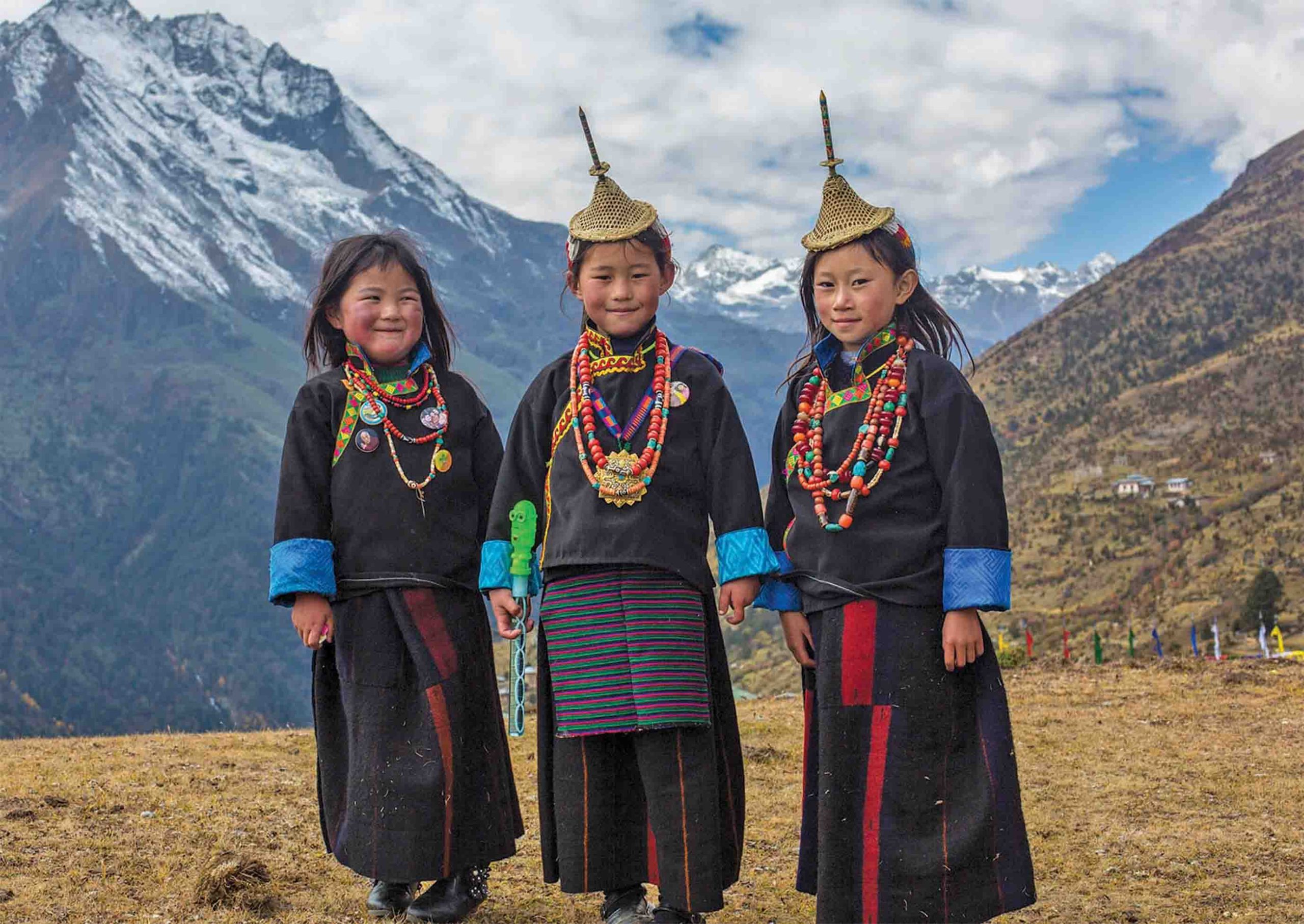
The trail winds up and down along the river until we climb up to Laya, one of the most distinctive villages in Bhutan, located on a shelf. As with most villages in the high Himalaya, cultivation is difficult. The villagers are semi-nomadic and rely on yak herding for a livelihood. They spend most of the year in black tents woven from yak hair but also build drystone-walled houses, which serve as shelter during the coldest months and as storehouses for the goods and grains that they barter with the central valleys.
The women of Laya wear unusual conical bamboo hats, turquoise and coral jewelry and (unlike most women in Bhutan) long hair. Most villagers are busy in the fall cultivating or harvesting crops of turnips, mustard and barley. Camp
Starting elevation: 11,700’ at Laya
Ending Elevation: 10,820’ at Koena
Distance: 9 miles
Elevation Gain: 800’
Elevation loss: 880’
Time: 5-6 hours
Descending from Taksimakhang through the craggy peak-lined valley, the rocky trail follows the Mo Chu (river) through a heavily forested area to Koena. There is a wooden hut with a fire pit which we can use. Camp
Starting elevation: 10,820’ at Koena
Ending Elevation: 8.200’ at Gasa hot springs
Distance: 14 miles
Elevation Gain: 2,230’ (Bale la 13,050’)
Elevation loss: 4,850’ from bale la
Time: 7-8 hours
The day begins with a long climb to the Bale La (13,050’) and then continues up and down until we reach Gasa. About an hour of walking down the steep trail brings us to a hot springs, where you can enjoy a long-anticipated soak. (Be forewarned that this day can be very muddy if it is raining.) Camp
Starting elevation: 8,200’ at Gasa
Ending Elevation: 8,300’ at Goem Damji
Distance: 8 miles
Elevation Gain: minimal about
Elevation loss: minimal about 100 ft
Time: 5-6 hours
A morning soak (for those who rise early!) before we climb out of the valley and onward over an up-and-down trail. Although our destination is lower than our starting point, the day entails a fair amount of climbing. Depending on the season, this area is usually where leeches are encountered. Then drive to Punakha for 2 hours. Hotel
(Note: This itinerary is a sample itinerary intended to give you a general idea of trip to Bhutan. We can tailor an itinerary to suit your requirements and interests. Please Contact Us to design the exact itinerary for you)